


The two surviving copies of the 1525 Moscovia map by Paolo Giovio: A comparative study
BY |
UA |
EN |
RU
DOI:
|
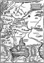
Abstract The first printed map carrying name “Moschovia” in its title was compiled in Rome in 1525 by Paolo Giovio (1483–1552). He announced it in Libellus de legatione Basilii magni (Rome, 1525), a book he published based on his conversations with Dimitri Gerasimov, an envoy to Pope Clement VII from Grand Duke Vassily III of Moscow. The map’s importance transcends Muscovy, extending to the other medieval Rusian states: the Grand Duchy of Lithuania and Novgorod Republic, the lands of the sedentary and nomadic successors of the Mongol Empire (Tartaria), as well as the modern states of Ukraine, Lithuania, Poland, Belarus, and the Russian Federation. For a long time, only several manuscript renditions of the 1525 map were known issued in 1550s by the Venetian mapmaker Battista Agnese, while the printed version was presumed lost. An article in Imago Mundi Vol.72:1 (2020) reported the discovery of an original imprint of the 1525 map back in 2006 at Biblioteca Marciana in Venice. In fact, this was the second known imprint of the map. The first one was sold on December 7, 1993, by Sotheby's in London and subsequently made its way to the Russian State Archive of Ancient Acts (RGADA) in Moscow. A comparative study of the two imprints leads to a conclusion that the RGADA copy is a proof pulled to make the necessary corrections, which can now be seen in the Venice copy. Besides, a thorough analysis of Giovio’s printed map and other sources reveals that the title date, October 1525, corresponds to the time of the interviews, not the time when the map was created, and provides cartographic evidence proving that Dimitri Gerasimov contributed no cartographic materials and had no role in compilation of the map. |
|
| < Папярэдні | Наступны > |
|---|