


BY | EN
[DOI:]
IMAGO.by
17.04.2026
Tadeusz Korzon’s Plan of Minsk from the 2nd Half of the 18th Century as a Source for Research on the City’s Historical Topography*
This article presents an analysis of two variants of the Plan of the City of Minsk from the Second Half of the Eighteenth Century, prepared by the Minsk engineer Tadeusz Korzon on the basis of archival sources and executed in 1934 and 1936. They constitute a unique topographical reconstruction of the city—now the capital of present-day Belarus—prior to its incorporation into the Russian Empire. The plans were compared with surviving Russian survey plans and archival materials, which made it possible to verify their reliability and determine the degree of their consistency with the sources. The study discusses the urban structure of Minsk in the second half of the eighteenth century, the street network and its variant nomenclature, fortifications, key sites, and private residences. Korzon’s plans bridge the gap between written sources and later Russian plans and constitute a valuable tool for research on the historical topography of the city.
Keywords: Minsk in the eighteenth century; city plan; Tadeusz Korzon (engineer); historical cartography; urban topography; historical urban studies; plan reconstruction; archival sources.
Introduction
During the period of the Polish–Lithuanian Commonwealth, Minsk served as the capital of a voivodeship. However, in comparison with other cities of similar status, relatively few plans and other graphic sources dating from before the Second Partition have survived. From 1793 onwards, the Russian administration began to produce plans of Minsk on a regular basis—both survey and design plans1.
Against this background, particular significance attaches to the detailed reconstruction of the plan of Minsk from the second half of the eighteenth century, developed in the 1920s and 1930s on the basis of archival sources by the Minsk engineer Tadeusz Korzon. Preserved in the form of two plans from 1934 and 1936, this work makes it possible not only to reconstruct the architectural layout of Minsk at the end of the eighteenth century, but also to identify a number of features not known from other sources. A comparison of Korzon’s plan with other surviving plans and archival documents allows for a critical assessment of its historical reliability.
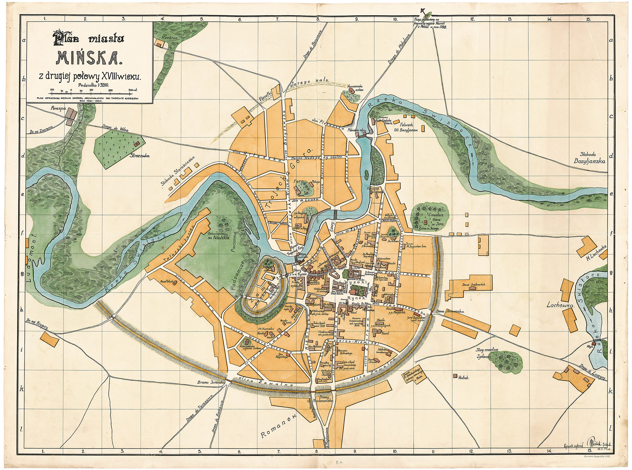
The reconstruction plan by Tadeusz Korzon is dated to 1934 and is held in the Cartographic Collections Department of the National Library of Poland under the reference number ZZK 9429. The drawing was executed in color on a sheet measuring 92 × 69 cm. The cartouche states that the plan was prepared on the basis of archival sources (without specifying whether these included cartographic materials) by the engineer Tadeusz Korzon in the “1920s–1930s.” The fair copy was produced by B. Pieślak in 1934 (Fig. 1).
Surviving evidence points to earlier attempts to reconstruct this plan. In 1918, an exhibition of antiquities and works of art was held in Minsk. In the exhibition catalogue, in the section “Old Plans and Views,” the following entry was recorded: “Plan of the city of Minsk. Prepared on the basis of old plans and information by Eng. T. Korzon. It presents a picture of Minsk up to 1790.”2 The subsequent fate of this item remains unknown; however, it is reasonable to assume that Korzon’s later plans were based on this earlier work. Particularly significant is the note that the 1918 plan was prepared, among other things, “on the basis of old plans.”
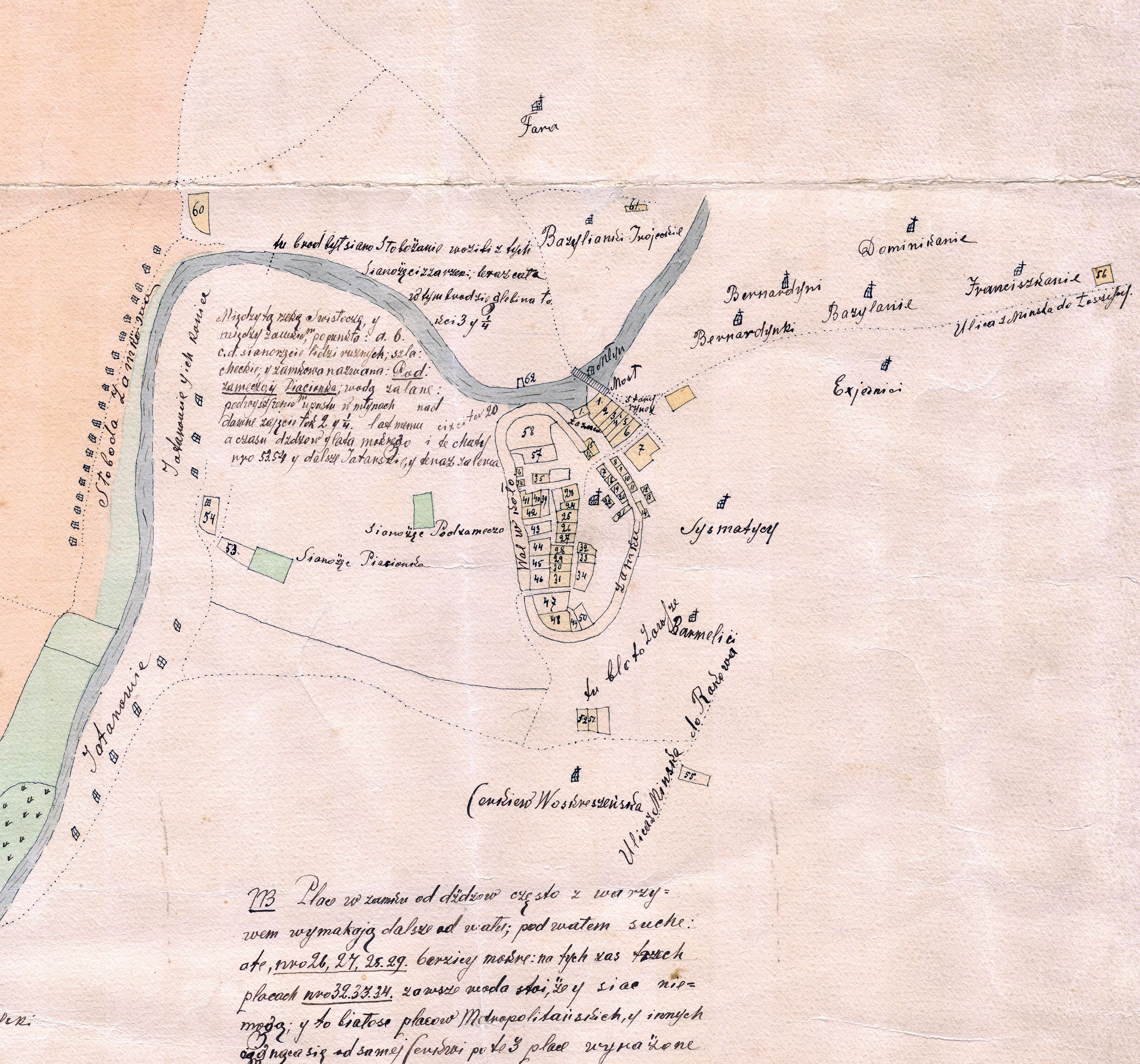
The 1918 exhibition was associated with the Belarusian national movement activist Ivan Luckievič (1881–1919), and part of the exhibits originated from his collection3. His name is also linked to another well-known plan of the castle jurydyka districts of Minsk from 1783, in which the city is depicted in a rather schematic manner: sacral landmarks are indicated, and plots of ownership in the castle square are numbered (Fig. 2).
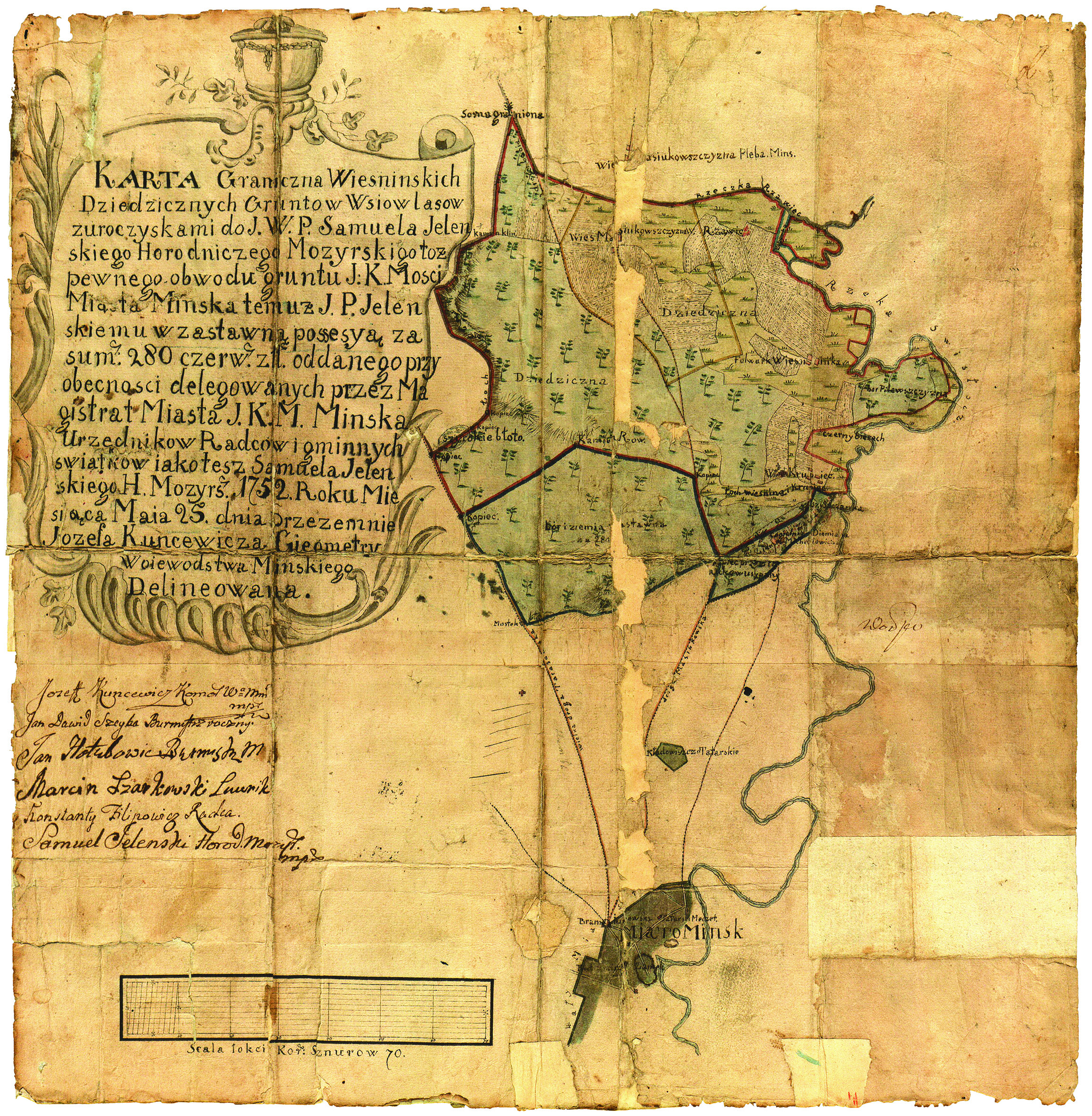
In addition to the so-called Luckievič plan, another map of the environs of Minsk from 1752 is known, showing private landholdings in the north-west; on this map, the outline of the city is only fragmentarily depicted (Fig. 3). These materials merit attention in view of the critically small number of early original plans of Minsk.
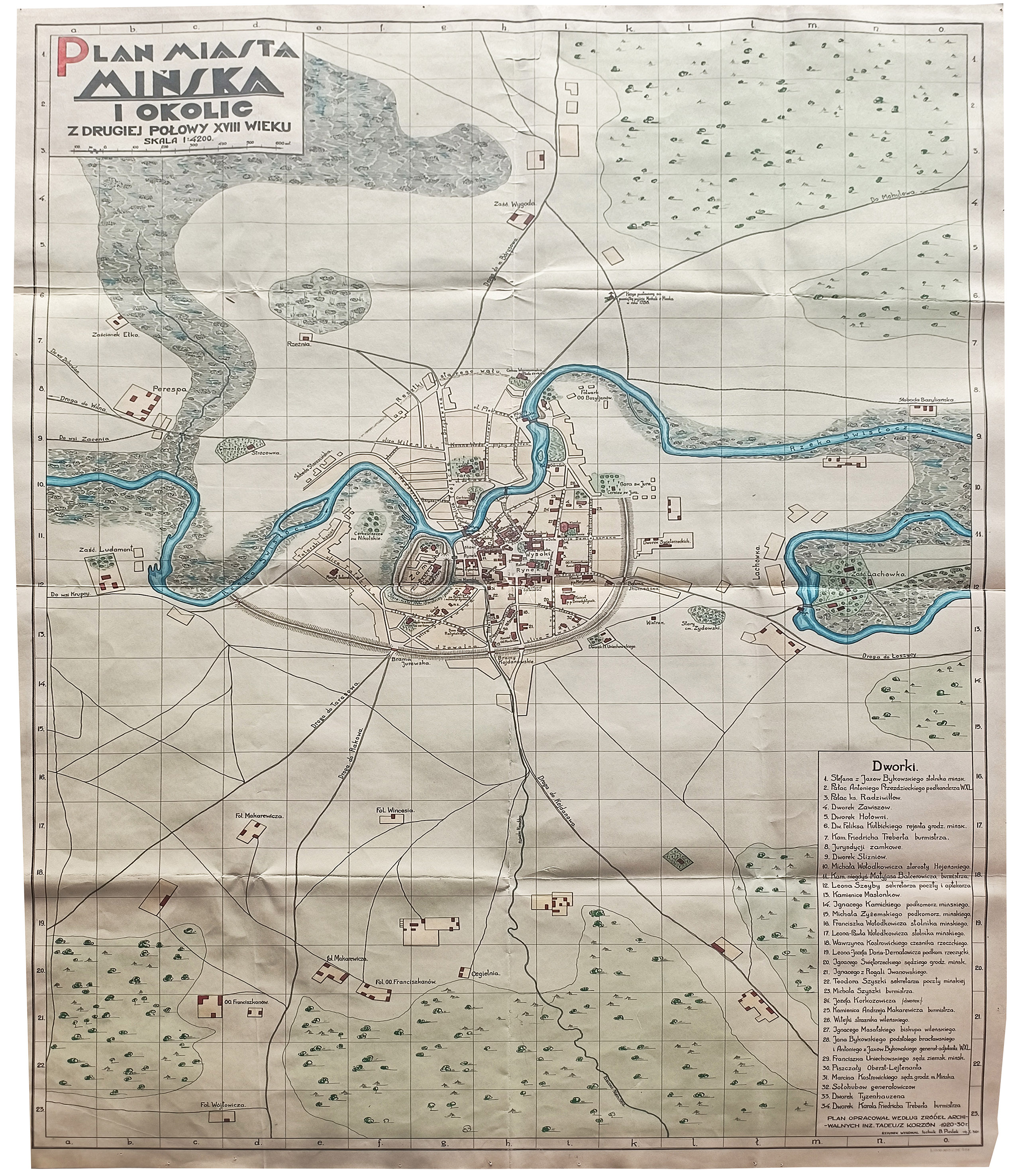
It is worth noting that the National Library of Poland holds a second variant of Tadeusz Korzon’s plan (Fig. 4), dated to 19364. This version is distinguished by its larger format and contains additional information concerning the areas adjacent to Minsk. This matter will be discussed in greater detail further in the text.
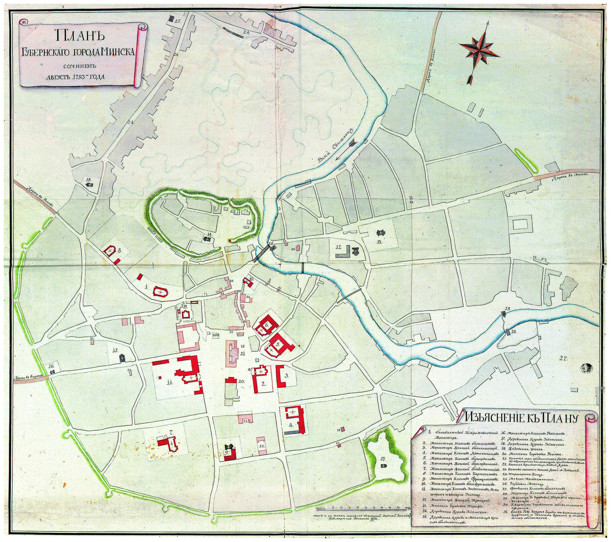
The next known plan of Minsk, already as a “gubernial city,” was prepared in August 1793 by a Russian district surveyor (Fig. 5). Russian plans were more precise, but typically focused on strategic information: fortifications, bridges, more important masonry buildings, and distinctive topographical features of the terrain. As early as 1797, the first design plan appeared, envisaging a geometric layout of the city’s block-based development. The first Russian plan to present the city’s street network in detail dates only from 18585.
Unlike earlier plans (1752 and 1783), the two plans from 1934 and 1936 are more fully developed and contain unique information not found in later Russian plans: the names of townhouse owners and noble residences, street names, the layout of market squares and fortifications, and other features poorly known from other sources.
Author of the Plan
The author of the plan is Tadeusz Korzon, born in 18766. Like his older brother Władysław, he graduated from the St. Petersburg Institute of Technology7. The Korzon family bore the coat of arms Morski Kot; the same coat of arms was also used by another branch of the Minsk Korzon family, to which the well-known historian Tadeusz Korzon (1839–1918) belonged8.
Engineer Tadeusz Korzon was a prominent figure in the life of the city: he managed the municipal power plant in Minsk in 1905–1906 and again in 1911–1920. For a time, he worked in Germany, after which he returned to Minsk in 1910. In 1919–1920, he held the position of first deputy mayor, being responsible for the city’s municipal economy. In 1912–1913, he developed a project for an electric tramway in Minsk, which, however, was not implemented at the time. After the city was taken by the Bolsheviks in 1920, Korzon left and did not return9.
Korzon was a member of the Minsk Section of the Warsaw Society for the Protection of Historical Monuments, which had been active since 1916. Owing to the activities of this society, around fifty rescue and inventory expeditions were organized; public lectures were delivered, and two exhibitions of art and historical monuments were held in Minsk in 1916 and 191710. A record of a lecture on old Minsk delivered by Tadeusz Korzon in February 1920 has been preserved11, suggesting that beyond his professional duties he was engaged in research on the city’s history and its popularization.
The materials collected by the Minsk Section were transferred to Warsaw in 1918 and have been partially preserved (Zbiór Materiałów Mińskiego Koła Warszawskiego Towarzystwa Opieki nad Zabytkami Przeszłości, AGAD, sygn. 1/202/0). Among these materials, however, only one map has been identified: Mappa Nowego miasta, koszarów i Lachówki przez uczniów wyższych czterech klas wymierzona 1804 roku (AGAD, ref. no. 1/202/0/7/47).
Content of the 1934 Plan
Korzon’s plan of 1934 was drawn in Polish, at a scale of 1:3,200, and is oriented towards the north-east. An orientation with a slight deviation from the north axis was not uncommon on Russian plans from the late eighteenth and nineteenth centuries; however, by the early twentieth century it was already regarded as outdated. When overlaid onto modern maps, the plan does not maintain full consistency of scale. The plan field is divided into squares marked with letters and numbers, but these have no functional significance; there is also no legend that might explain them.
The Svislach River (Świsłocz) was taken as the basis for the topographical drawing (the direction of its flow is indicated). The small Nyamiha River (Niemiga), known from medieval chronicles, flows into the Svislach near the castle. Further upstream, the river Tsna (unlabelled) joins it.
On the plan, three urban complexes can be distinguished, belonging to different stratigraphic stages of the city’s development: the Castle, surrounded by a moat (shown as the former riverbed of the Svislach River); Trojecka Hill on the left bank of the Svislach; and the High Market on the right bank.
The oldest part of the city consists of the Castle and the Lower Market (on the plan labelled as the Old Market). Functionally, the Lower Market connected the Castle, the foot of Trojecka Hill on the opposite bank from the castle (marked on the plan as the Market of the Trojecka parish church), as well as the slope of the right bank below the course of the Svislach, where a river landing has existed since the Middle Ages.
The castle on the Svislach River was founded in the last third of the eleventh century; it served as the southern defensive outpost of the Principality of Polotsk and controlled the routes along the upper course of the Svislach12. On the basis of toponymy, it has been suggested that Trojecka Hill, on the opposite bank from the castle, may have been an earlier centre of urban settlement13. However, archaeological research has not confirmed the presence of genuinely early material.
Archaeological material from the area of the river landing—which constitutes a second hypothesized “point of origin” of the city (marked on the plan as Ławy [market stalls] and the area of Bernardyńska Street)—is also rather limited and does not date earlier than the twelfth century14.
The Lower Market was intersected by transit routes running from Barysaw and Mahilyow (towards Moscow) to Rakaw and Koydanava (towards Warsaw). From Trojecka Hill began the Vilnius road (leading via Radashkovichy and Maladzyechna). A bridge over the Svislach had long been in use, while further upstream the river could be crossed at a ford15. The High Market as an urban centre took shape only in the seventeenth and eighteenth centuries.
Only fragmentary information has survived regarding the nature of Minsk’s fortifications. Alexander Guagnini noted that Minsk was “a large wooden city, with a castle built of wood, naturally and advantageously situated, and fairly well defended, surrounded by a deep moat”16.
It is likely that by the mid-seventeenth century the castle had already taken the form of a bastion fortification. Following the occupation of the city by Muscovite forces in 1655, several towers and a small fortification were erected, and the entire complex was surrounded by water. These defences were constructed hastily; consequently, already in the following year the Muscovite garrison transformed the masonry buildings of the Upper Town (the High Market) into a defensive stronghold17.
In this respect, Russian plans depict with greater precision the ramparts, curtains, and the bastion on St George’s Hill. Such a defensive structure can be observed on the Russian plan of 1793: the earthworks are marked in green, and the city rampart terminates in a bastion on which a wooden Uniate church is indicated under no. 17. In the plans of 1934 and 1936, this area is instead marked as a cemetery with a church (Cmentarz. Góra św. Jura. Cerkiew św. Jerzego); these plans also include the names of the entrance gates. The right-bank part of the city is enclosed by a municipal rampart with gates: the Jurewska Gate on the roads from Rakaw and Tarasava, two gates on the side of Koydanava, and the Ihumeńska Gate. The left-bank part of the city was likewise fortified with a rampart—marked on the plan as the remains of an old rampart (resztki starego wału).
An important element of the content of the 1934 plan is the set of street names, presented in a relatively comprehensive manner (over 30 names). However, as in the case of the fortifications, archival sources provide fragmentary and not always consistent information on street names and their locations. A comparison of Korzon’s plan with the Russian survey plan of 1797 (on which only the main streets are labelled) revealed no discrepancies18.
Some of the streets of Minsk marked on Korzon’s plan have preserved—to a greater or lesser extent—their original courses along with their historical names, for example: Niemihska, Zamkowa, Woskresienska, and Zybicka. Other streets have survived but under names assigned during the period of the Russian Empire and later in the Soviet era, such as: Bernardyńska (street and lane), Dominikańska, Franciszkańska, Kojdanowska, Wołocka, and Zborowa (named after the Calvinist congregation), among others. Some former streets disappeared as a result of subsequent reconstructions and urban transformations of the city.
In this context, establishing the location of a “historical fact” when a street name is given in the sources generally poses no difficulty. Indicating the street was mandatory in documents relating to real estate, and was often supplemented with additional references to well-known buildings or other features19. Only a small number of streets mentioned in archival sources present interpretative difficulties. Written sources show that different names were used for the same streets (e.g. Felicjańska and Kojdanowska, Jurewska and Karmelicka), or that there existed semantically similar variants of their names. Some ambiguity also concerns Jurewska Street, which was located in different parts of the city.
On both plans, the Jurewska Gate and Jurewska Street are consistently indicated; both derive their name from the Church of St George (whose existence is attested from the sixteenth century). From the early eighteenth century, a Carmelite monastery was established on this street (the order itself had been active in Minsk since 1703), and the street was therefore also referred to as Karmelicka. The street marked as “Wołocka lub Białocerkiewska” likewise appears in the sources under the name Jurewska.
At the beginning of the seventeenth century, the Church of St George was relocated to another site (on Korzon’s plan it is shown on St George’s Hill—Góra św. Jura), and the name of the street gradually shifted along with it—although it appears that such movements of toponyms occurred rather slowly. The church was also known as the “White Church” (Biała cerkiew), hence the appearance of the name Białocerkiewska Street on the plan. However, the context of the sources usually makes it possible to identify which street is meant. An example is a record from the late seventeenth century: “…near the Church of St George, which they call the White Church, on one side by the cemetery of that church, … with its rear towards the rampart, opposite Wołocka Street, proceeding from the city on the right-hand side”20.
It should be noted that not all Minsk streets of the seventeenth and eighteenth centuries known from written sources are included on the plan—these are mostly smaller lanes, rarely mentioned and identifiable only with a certain degree of probability.
Some variant street names mentioned in archival records can be localized thanks to Korzon’s plan. For example, the street marked on the plan as Burmiwska–Nadbrzeżna more often appears under the name Zabereżna, although it seems that for some time the designation Burmistrzowska (or Burmiwska) was also in use21. The lane marked on the plan as Górno–Niemiska was likewise referred to as Krzywa Street22.
The streets Makowska and Haroszynska (located in the area of Tatarska Street)23, as well as Akulanska24 and Kiesinowska25 (probably situated somewhere between Wilenska Street and Burmiwska–Nadbrzeżna), and several others, have not yet been identified. At the same time, the plan includes a number of little-known street names (predominantly on Trojecka Hill). The analysis carried out demonstrates a high degree of consistency between the plan and archival materials, indicating that all the streets marked on the plan existed at least in the second half of the eighteenth century.
The plan by Tadeusz Korzon contains valuable information on various levels of urban infrastructure. It presents unique data on local place names and landscape features, which—together with the marked religious, memorial, administrative, industrial-economic, and private buildings—form a comprehensive topographical system of the city.
Only a small number of buildings from the seventeenth and eighteenth centuries have survived in Minsk. The appearance of some of them is known only from descriptions (for example, the parish church on Trojecka Hill, most Orthodox wooden churches, and many others). In this context, plans can help reconstruct the outlines of buildings (the number of apses, orientation, etc.). A comparison of Korzon’s plan with Russian plans indicates the greater graphic precision of the latter. In the 1934 plan, building outlines are rendered in a more schematic manner; however, it may be helpful that it indicates monastic complexes associated with churches, as well as other buildings belonging to these complexes (their forms and mutual arrangement).
Seven Orthodox churches are marked on the plan (additionally, the site of the former Church of St Nicholas is indicated). Only this plan shows the Church of the Ascension (Wozniesieńska) on the outskirts of the city, by the road leading towards Mahilyow. Between the Lower and High Markets, the infrastructure of the city’s Jewish community was concentrated, including a synagogue, a school, and market stalls (Kramy żydowskie).
Among the unique pieces of information it provides is also the location of the pharmacy and the post office26 at the beginning of Kośmo-Demjańska Street.
The plan also provides valuable information on private townhouses and the estates of the urban elite and landowners associated with the city: it marks the residences of the families Szyszko, Ratyński, Kastrowicki, Sliźeń, Sołohub, Świętorzycki, Przezdziecki, Iwanowski, Uniechowski, Bykowski, Piszczałko, Dernałowicz, Maślanko, Wołodkowicz, Balcerowicz, Makarewicz, Karnicki, Masalcki, Kurkowicz, Hołownia, Witejko, Żyżemski, Zawisza, and Trebert. On the High Market, the Radziwiłł Palace (no longer extant) is indicated. On Wołocka Street, the manor house of Tyzenhauz is marked (it has survived in a rebuilt form and is now known as the Wańkowicz House-Museum).
Along the Mahilyow road, a cross is marked commemorating the withdrawal of Muscovite troops from Minsk in 1788. This date establishes the upper chronological limit of the sources used by Tadeusz Korzon; however, most of the information they contain may derive from earlier decades. Some townhouses are labelled with the names and offices of their owners. These data sometimes refer to the 1760s–1770s or even earlier, which may be explained by a certain inertia in the stabilization of proper names in urban toponymy (names were adopted with some delay and could continue to be used long afterwards).
One of the more striking examples of a change of ownership that would have required updating, but is not reflected on the plan, is the designation of the Jesuit church, monastery, and college as still functioning and belonging to the Jesuits—despite the suppression of the order in 1773.
The plan was introduced into scholarly circulation relatively recently27, and its verification through comparison with archival sources is still ongoing. Nevertheless, comparison with materials contained in the municipal record books confirms its accuracy. For example, in the Minsk magistrate’s record book from 1677–1680, in a document concerning the sale of a plot with a townhouse on Kojdanowska Street, it was noted that the plot was located “at the corner between the street and the Krzywy lane, which leads from Kojdanowska Street to Zborowa Street, adjoining the plot of the... Stefan Kastrowicki…”28. Despite the considerable chronological gap between the sources, this type of information is legible on Korzon’s plan and to some extent corroborated—there appears a townhouse belonging to the Kastrowicki family, and at the very corner an unlabelled but clearly distinct building is also marked.
Content of the 1936 Plan
The second version of the plan (Fig. 4), as indicated on the map itself, is likewise based on archival materials compiled by Korzon; it is drawn at a larger scale (1:4,200) and in a significantly larger format (118 × 76 cm).
The plan covers adjacent suburban areas and additionally presents a number of estates. The topographical situation in the north-west is shown in greater detail, including the road network, another unlabelled burial site, a brickyard, and a whole group of folwarks (manorial farms). Along the road to Rakaw, the folwarks of Makarewicz (two separate ones), the Franciscans (also two separate ones), and Winces, as well as five additional folwarks without specified ownership, are indicated. The plan also depicts, with buildings marked, the topography of areas adjoining the city: Słoboda Bazyljańska and the settlements of Ludamont and Lachówka. It further shows the extent of forest complexes and marshland areas surrounding the city.
In the sections where it overlaps with the 1934 plan, the content of the plan largely repeats it, although several differences can be identified. On the 1936 plan, Górno-Niemiski Lane ends at Kojdanowska Street, while its further continuation is designated as Krzywa (on the 1934 plan, this street retains the name Górno-Niemiski Lane along its entire course). The Old Market is labelled as the Lower Market (Nizki Rynek).
There are also certain differences in the recording of the names of townhouse owners—generally speaking, a separately added overlay on the 1936 plan made it possible to include somewhat more additional information about the owners’ offices or to provide fuller forms of their names. In comparison with the 1934 plan, the townhouse of Ignacy Świętorzecki (no. 20) exchanged places with that of Franciszek Uniechowski (no. 29), which was probably the result of an imprecise transfer of data to the overlay. The site marked on the 1934 plan as the Pharmacy and Post Office is numbered 12 on the 1936 plan, and its overlay indicates that it was the residence of Leon Szeyba, secretary of the post and apothecary29.
Additionally, in comparison with the 1934 plan, a manor house of Feliks Kublicki, regent of the Minsk castle court, is recorded on the castle square under no. 6. This name also appears on the so-called Luckievič plan of 1783, where, under no. 58, in the same location on the castle site, the residence is marked as the “House of the noble Piotuch family”30. References to Feliks Kublicki-Piottuch, regent of the Minsk voivodeship castle court, are also preserved in court records—he appears as a party in a property dispute concerning the Kopiejewicze estate, conducted in the 1770s and attested in a source dated 5 August 1782, against the Radziwiłł family31.
Conclusions
A comparison of Korzon’s plans with the known Russian plans of Minsk from this period indicates the distinct character of this source. Given the accuracy and the clear, coherent form of representation, it may be assumed that the reconstruction was based on a previously unknown original plan (or a set of such plans) created in the late 1780s and supplemented with narrative archival sources.
No significant errors have been identified in the plan, and certain discrepancies with written sources can be explained by the multiplicity of toponyms then in use. The plan provides the earliest known socio-topographical image of the city, reflecting the situation in the 1770s–1780s. It may also assist in locating earlier written records containing topographical data and can serve as a tool for the historical reconstruction of social and economic relations at a pivotal moment in the city’s history.
The plan contains a layer of unique information: the names and locations of little-known streets, historical toponyms (some of which have survived in the toponymy of modern Minsk), the names of property owners and the locations of private buildings, as well as other spatial data, including the boundaries and extent of marshlands and forest complexes.
The greatest interpretative difficulties arise in relation to smaller streets and lanes. The limited number of surviving historical sources (especially from the seventeenth century and earlier) makes it difficult to fully reconstruct the dynamics of the spread of urban toponyms in Minsk in the seventeenth and eighteenth centuries.
The plans by Tadeusz Korzon constitute a unique tool for reconstructing Minsk in the second half of the eighteenth century. The critical use of this reconstruction, combined with archival materials, makes it possible to recover the lost image of the city prior to its imperial transformation. Korzon’s plans are significant not only for historians, but also for architects, urban planners, and all those engaged in restoring the historical and cultural memory of Minsk.
Figures
* Extended version of the article published as: „Plan miasta Mińska z drugiej połowy XVIII wieku” inżyniera Tadeusza Korzóna. Treść topograficzna i przydatność historyczna źródła, Z dziejów kartografii: Społeczna rola kartografii, 2026, t. 26, pp. 205–218.
The author would like to express his gratitude to Yury Snapkouski for his invaluable assistance with genealogical research concerning the Korzon family.
1 I. Andreyeu, V. Andreyeva, and P. Rastoucau, Minsk na staradaŭnih kartah i planah [Minsk on Historical Maps and Plans] (Minsk, 2021).
2Katalog Minskoj oblastnoj vystavki drevnostej i izjaščnyh izdelij [Catalogue of the Minsk Regional Exhibition of Antiquities and Fine Crafts], comp. A. Ippelʹ (Minsk, 1918), 5.
3 V. Šmataŭ, “Lia vytokaŭ” [At the Origins], Spadčyna, no. 2 (1992): 4–12.
4Plan miasta Mińska i okolic: z drugiej połowy XVIII wieku : podziałka 1:4 200, 1936. National Library of Poland, Cartographic Collections, ref. no. ZZK 9430.
5 I. Andreyeu, V. Andreyeva, and P. Rastoucau, Minsk na staradaŭnih kartah i planah, 104–107.
6Herboŭnik bielaruskaj šlachty [Armorial of the Belarusian Nobility], vol. 8, pt. 1 (Minsk, 2022), 674, entries no. 182/88 (Tadeusz) and no. 180/88 (Władysław).
7 Central State Historical Archive in St. Petersburg (ЦГИА СПб.), f. 492, op. 2, d. 5372; f. 492, op. 2, d. 4721.
8Herboŭnik bielaruskaj šlachty, 663–664; J. Kołbuszewska, Tadeusz Korzun (1839–1918) (Łódź, 2011), 82–83.
9Minski magistrat i haradskaja rada ŭ dakumentach (1919–1920), ed. A. Daškevič and A. Skepʹjan (Minsk, 2020), 13, 31, 347; Andreyeu et al., Minsk na staradaŭnih kartah i planah, 62–63; L. Laŭreš, “Minskaja elektrastancyja” [The Minsk Power Plant], Maladoscʹ, no. 1 (2016): 108–113.
10Tygodnik Illustrowany, no. 20–21 (1918): 254–255.
11 S. Ablamejka, Nieviadomy Minsk. Historyja zniknennia, bk. 1 (2021), 87.
12 S. Temušeŭ, “Datirovanie i obstojatelʹstva skladyvanija Menskoj volosti Polockoj zemli” [Dating and the Formation of the Minsk District of the Polotsk Land], in Minsk i minčane. Dzieśać stahoddziaŭ historyi. Da 955-hoddzia horada (Minsk, 2023), 20–33.
13 R. Borovoj, “Istoričeskaja topografija drevnego Minska. Obzor istočnikov i sovremennoe sostojanie problemy” [Historical Topography of Early Minsk: A Survey of Sources and the Current State of Research], Histaryčna-archealagičny zbornik, no. 12 (Minsk, 1997).
14 Ju. Zajac, “Mensk na Svisloči konca XI–XIII vv. Problema formirovanija poselenčeskoj struktury” [Minsk on the Svislach in the Late 11th–13th Centuries: The Problem of the Formation of the Settlement Structure], in Minsk i minčane. Dzieśać stahoddziaŭ historyi (Minsk, 2008), 30.
15 The ford is also marked on the Luckievič plan of 1783, with a note indicating that after raising the weir at the mills, the water level increased significantly.
16 A. Gwagnin, Kronika Sarmacji europejskiej (Kraków, 1611), bk. 2, pt. 2, 112.
17 M. Tkačev, Zamki Belarusi (Minsk, 2002), 47–54.
18 Andreyeu et al., Minsk na staradaŭnih kartah i planah, 70–71.
19 N. Paltaržyckaja, “Nazvy vulic i vulachak Menska ŭ aktach mahistrackich knih 1663–1680 hh.” [Street and Lane Names of Minsk in the Records of the Magistrate Books, 1663–1680], in Minsk i minčane: dzieśać stahoddziaŭ historyi. Da 955-hoddzia horada (Minsk, 2023), 101.
20 National Historical Archives of Belarus (НГАБ), f. 1816, vop. 1, spr. 54, fols. 1002–1005 verso, cited in Paltaržyckaja, “Nazvy vulic i vulachak Menska…,” 104.
21 Paltaržyckaja, “Nazvy vulic i vulachak Menska…,” 102. The author also records the street name Burniewska (Бурнеўская), ibid., 108.
22 This follows from the context of archival records concerning property ownership. See Paltaržyckaja, “Nazvy vulic i vulachak Menska…,” 108.
23 Paltaržyckaja, “Nazvy vulic i vulachak Menska…,” 106; U. Paškievič, “Aktavaja kniha Minskaha mahistrata 1702–1732 hh. jak krynica pa sacyjalna-ekanamičnaj historyi horada” [The Record Book of the Minsk Magistrate (1702–1732) as a Source for the Socio-Economic History of the City], in Minsk i minčane: dzieśać stahoddziaŭ historyi. Da 955-hoddzia horada (Minsk, 2023), 114.
24 Paltaržyckaja, “Nazvy vulic i vulachak Menska…,” 109.
25 Ibid., 109–110.
26 At the Sejm of 1717, a permanent postal route was established from Vilnius to the Russian border via Minsk and Mahilyow; in 1721, permission was granted to establish postal communication between Minsk and Navahrudak as tribunal cities. See A. Chmara and A. Jelski, “Mińsk, Mińszczyzna,” in Słownik geograficzny Królestwa Polskiego i innych krajów słowiańskich, vol. 6, 462–463.
27 First published in: Andreyeu et al., Minsk na staradaŭnich kartach i planach, 60–63.
28 НГАБ, f. 1816, vop. 1, spr. 54, cited in Paltaržyckaja, “Nazvy vulic i vulachak Menska…,” 108.
29 Archivists are more familiar with the figure of Jan Dawid Szeyba (b. 1711 – d. after 1763), an apothecary who in 1748 obtained a privilege to operate a pharmacy and later served as secretary of the post (from 1758) as well as mayor of the city. It is also known that in 1782–1783 Leon Szeyba, mentioned on the plan, applied to the Minsk land court for copies of this privilege, most likely in connection with the transfer of the pharmacy to a descendant or relative of Jan Dawid. See A. Doŭnar, “Rejestr dokumentaŭ minskaha burmistrа Jana Davida Šejby” [Register of Documents of the Minsk Mayor Jan Dawid Szeyba], in Minsk i minčane: dzieśać stahoddziaŭ historyi (Minsk, 2008), 99.
30 On the Luckievič plan, only plot numbers are indicated; the list of residents can be reconstructed from the Inwentarz jurydyk zamkowych of 1783, which effectively serves as an explication of the plan, preserved in the National Historical Archives of Belarus (НГАБ), f. 1928, vop. 1, spr. 172.
31 “Aktor WJP. Felix Kublicki Piottuch, Regent Grodzki Wdztwa Mińskiego, Pozwani JOO. XX. Jchmość Albrycht Generał-Major Oyciec, Dominik Porucznik Wóysk W.X. Litt. Syn, Radziwiłłowie,” n.d., [s.n.], accessed April 15, 2026. https://rcin.org.pl/ibl/Content/51892.
Literature
Chmara, A., and A. Jelski. 1885. “Mińsk, Mińszczyzna.” In Słownik geograficzny Królestwa Polskiego i innych krajów słowiańskich, vol. 6.
Gwagnin, A. 1611. Kronika Sarmacji europejskiej. Kraków.
Kołbuszewska, J. 2011. Tadeusz Korzun (1839–1918). Łódź.
Tygodnik Illustrowany. 1918. Nos. 20–21.
Абламейка, С. (Ablamejka, S.). 2021. Невядомы Менск. Гісторыя зьнікненьня, кн. 1. Мінск.
Андрэеў, І., Андрэева, В. і Растоўцаў П. (I. Andreyeu, V. Andreyeva, and P. Rastoucau). 2021. Мінск на старадаўніх картах і планах (Minsk na staradaŭnih kartah i planah). Мінск.
Боровой, Р. (Borovoj, R.). 1997. “Историческая топография древнего Минска. Обзор источников и современное состояние проблемы” (Istoričeskaja topografija drevnego Minska. Obzor istočnikov i sovremennoe sostojanie problemy). Гістарычна-археалагічны зборнік (Histaryčna-archealagičny zbornik), № 12. Мінск.
Гербоўнік беларускай шляхты (Herboŭnik bielaruskaj šlachty). 2022. Т. 8, ч. 1. Мінск.
Доўнар, А. (Doŭnar, A.). 2008. “Рэестр дакументаў мінскага бурмістра Яна Давіда Шэйбы” (Rejestr dokumentaŭ minskaha burmistrа Jana Davida Šejby). In Мінск і мінчане: дзесяць стагоддзяў гісторыі. Да 940-годдзя горада. Мінск.
Заяц, Ю. (Zajac, Ju.). 2008. “Менск на Свислочи конца XI–XIII вв. Проблема формирования поселенческой структуры” (Mensk na Svisloči konca XI–XIII vv. Problema formirovanija poselenčeskoj struktury). In Мінск і мінчане: дзесяць стагоддзяў гісторыі. Да 940-годдзя горада. Мінск.
Каталог Минской областной выставки древностей и изящных изделий (Katalog Minskoj oblastnoj vystavki drevnostej i izjaščnych izdelij). 1918. Сост. А. Иппель. Мінск.
Лаўрэш, Л. (Laŭreš, L.). 2016. “Мінская электрастанцыя” (Minskaja elektrastancyja). Маладосць (Maladoscʹ), № 1.
Мінскі магістрат і гарадская рада ў дакументах (1919–1920) (Minski magistrat i haradskaja rada ŭ dakumentach). 2020. Падр. А. Дашкевіч, А. Скеп’ян (Daškevič, A., and A. Skepʹjan, eds.). Мінск.
Палтаржыцкая, Н. (Paltaržyckaja, N.). 2023. “Назвы вуліц і вулачак Менска ў актах магістрацкіх кніг 1663–1680 гг.” (Nazvy vulic i vulačak Menska ŭ aktach mahistrackich knih 1663–1680 hh.). In Мінск і мінчане: дзесяць стагоддзяў гісторыі. Да 955-годдзя горада. Мінск.
Пашкевіч, У. (Paškievič, U.). 2023. “Актавая кніга Мінскага магістрата 1702–1732 гг. як крыніца па сацыяльна-эканамічнай гісторыі горада” (Aktavaja kniha Minskaha mahistrata 1702–1732 hh. jak krynica pa sacyjalna-ekanamičnaj historyi horada). In Мінск і мінчане: дзесяць стагоддзяў гісторыі. Да 955-годдзя горада. Мінск.
Темушев, С. (Temušeŭ, S.). 2023. “Датирование и обстоятельства складывания Менской волости Полоцкой земли” (Datirovanie i obstojatelʹstva skladyvanija Menskoj volosti Polockoj zemli). In Мінск і мінчане: дзесяць стагоддзяў гісторыі. Да 955-годдзя горада. Мінск.
Ткачёв, М. (Tkačev, M.). 2002. Замки Беларуси (Zamki Belarusi). Мінск.
Шматаў, В. (Šmataŭ, V.). 1992. “Ля вытокаў” (Lia vytokaŭ). Спадчына (Spadčyna), №2.
Archival Sources
Central State Historical Archive in St. Petersburg (ЦГИА СПб.): f. 492, op. 2, d. 5372; f. 492, op. 2, d. 4721.
National Historical Archives of Belarus (НГАБ): f. 1928, vop. 1, spr. 172. Інвентар юрыдык Мінскага замку, 1783.
Central Archives of Historical Records in Warsaw (AGAD): Zbiór Materiałów Mińskiego Koła Warszawskiego Towarzystwa Opieki nad Zabytkami Przeszłości, ref. no. 1/202/0.
Cartographic Sources
Plan miasta Mińska z drugiej połowy XVIII wieku. 1934. National Library of Poland, Cartographic Collections, ref. no. ZZK 9429.
Plan miasta Mińska i okolic z drugiej połowy XVIII wieku. 1936. National Library of Poland, Cartographic Collections, ref. no. ZZK 9430.
Karta Graniczna Wieśninskich Dziedzicznych Gruntow Wsiow Lasów z uroczyskami… 1752. National Historical Archives of Belarus (НГАБ), f. 147, vop. 3, spr. 24857, ark. 199.
Plan mińskich jurydyk zamkowych (Luckievič plan). 1783. National Historical Museum of Belarus, ref. no. НД 6796.
План губернскаго города Минска. Сочинён в августе 1793 года. 1793. Russian State Military Historical Archive (РГВИА), f. 846, op. 16, d. 22147.
| < Папярэдні | Наступны > |
|---|